

-
1.
-
2.
-
3.
-
4.
-
5.
If you enjoy night or ocean kayaking or will be paddling in large lakes or unfamiliar waters, having the best kayak GPS is crucial. It will give you the freedom to explore without the fear of getting lost. To help you find a kayaking GPS you can count on every time, our reviews below take a look at the best kayak GPS units on the market.
When choosing the best GPS for kayaking and hiking, it’s important to ensure that its accuracy is spot on. Depending on the kind of paddling adventures you enjoy, you can opt for a GPS fish finder, a marine chart plotter, or a VHF radio with GPS. For more information on the options available and how to choose the best kayak GPS for your needs, be sure to check out the buying guide right below the reviews.
OUR TOP PICK
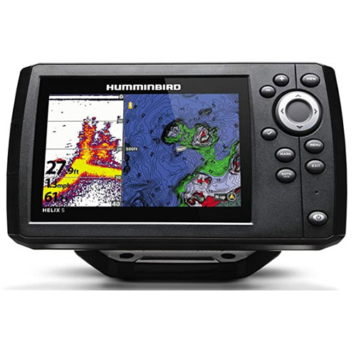
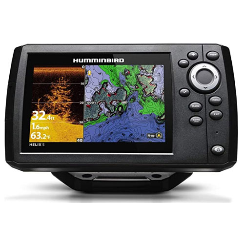
Hummingbird Helix 5 Chirp
- Stand Out Features - Why We Love It
- Best For: Fishing kayak GPS fish and depth finder
- Precision GPS/WAAS receiver is accurate within 2.5 meters
- CHIRP dual beam sonar shows fish and structure with crystal clarity
- Basemap provides a clear view of underwater terrain
- AutoChart Live allows you to create real-time maps
- Built-in Anima cartography for chart plotting
- 5-inch WVGA display is sunlight-readable and has backlight
- Long battery life
Type of Device: GPS Fish Finder
GPS: WAAS-enabled Receiver
Sonar: Dual-Beam CHIRP
Display: 5 inches, 800H X 480V pixels
Dimensions: 1.13 x 7.55 x 4.28 inches
Weight : 2.5 pounds
EDITORS CHOICE
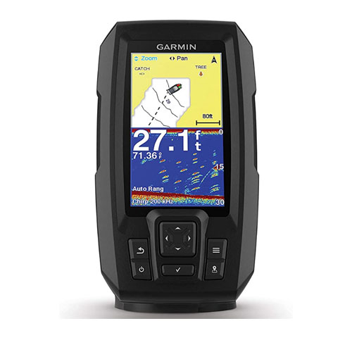
Garmin Striker 4 Plus Built-In
- Stand Out Features - Why We Love It
- Best For: Contour mapping the waters you explore
- Built-in mapping software enables you to create and store HD maps
- CHIRP traditional sonar and dual-Beam transducer
- Accurate kayak speedometer and depth reader
- 4.3 inch display is sunlight-readable and has a night mode
- Rugged build with IPX7 water resistance rating
Type of Device: GPS Fish Finder
GPS: Internal
Sonar: CHIRP Traditional and Dual-Beam Transducer
Display: 4.3 inches, 272 X 480 pixels
Dimensions: 3.9 x 1.8 x 6.9 inches
Weight : 11.2 ounces
BEST VALUE
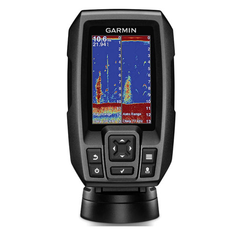
Garmin Striker 4 CHIRP Fish Finder
- Garmin Striker 4 CHIRP Fish FinderStand Out Features - Why We Love It
- Best For: Value for money, GPS kayak speedometer
- Uses traditional CHIRP sonar and ClearVu scanning sonar
- High-sensitivity depth reader and speed display in miles or knots
- Delivers near photographic images of fish and structure
- Real time display of fish even at higher speeds
- Classic flasher format for ice fishing and vertical jigging
- Long battery life and water resistant
Type of Device: GPS Fish Finder
GPS: Internal
Sonar: CHIRP and ClearVu
Display: 3.5-inch, 480 x 320 pixels
Dimensions: 3.6 x 1.6 x 5.9 inches
Weight : 8 ounces
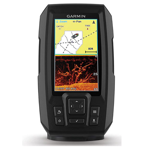
Garmin eTrex 22x Worldwide Handheld

- Stand Out Features - Why We Love It
- Best For: Compactness, 8GB internal memory
- Supports both GPS and GLONASS satellite systems
- Preloaded with TopActive maps with routable roads and trails
- 8GB internal memory and MicroSD card slot for downloading maps
- Supports geocaching and allows you to upload GPX files
Device Type: GPS Navigator
GPS: GPS and GLONASS
Mapping: TopoActive
Display: 2.2 Inches, 240 x 320 pixels
Dimensions: 1.3 x 4 x 2.1 inches
Weight: 5 ounces
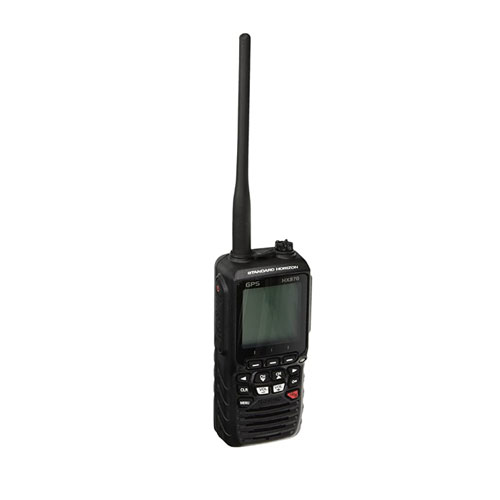
STANDARD HORIZON HX870 Floating VHF Handheld
- Stand Out Features - Why We Love It
- Best For: Ocean kayaking
- 66 Channel WAAS GPS receiver is quick and accurate
- 70-Channel DSC is up to ITU-R M493-13 standards
- Distress button and a water-activated emergency strobe
- Man overboard function and group monitoring feature
- Floating and waterproof up to the highest IPX8 standard
- Long battery life
Device Type: 6W VHF Radio with DSC
GPS: Integrated 66 Channel WAAS Receiver
Impedance: 50 Ohm
Dimensions: 9.5 x 3.5 x 7.5 inches
Weight: 2 Pounds
Garmin Striker 4cv Fish Finder
- Stand Out Features - Why We Love It
- Best For: ClearVu scanning sonar
- Advanced fish finder with CHIRP technology and ClearVu sonar
- Track feature allows you to mark waypoints and create routes
- Built-in Quickdraw contours mapping software for creating maps
- Intuitive user interface is pretty easy to figure out
- Large and bright 4.3” display is visible in all conditions
Type of Device: GPS Fish Finder
GPS: Internal
Sonar: CHIRP, ClearVu
Dimensions: 3.9 x 1.8 x 6.9 inches
Weight : 11.2 ounces
Garmin GPSMAP 78sc Chartplotter Marine
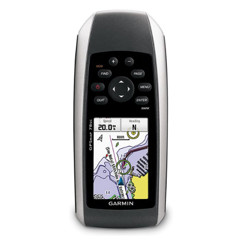
- Stand Out Features - Why We Love It
- Best For: Built-in BlueChart g2 coastal charts of the U.S. and Bahamas
- WAAS GPS, HotFix satellite prediction, and a worldwide Basemap
- Dedicated MOB (man over board) button
- Custom maps and BirdsEye Satellite Imagery compatible
- Tilt-compensated 3-axis compass and barometric altimeter
- Handheld unit with molded rubber side grips
- Waterproof to IPX7 standards and floats in water
- Long battery life
Type of Device: GPS Navigator, Chart Plotter
GPS: WAAS-enabled GPS, HotFix
Charts: BlueChart g2 coastal charts of the U.S. and Bahamas
Display: 2.6 inches
Dimensions: 2.6 x 1.2 x 6 inches
Weight : 7.7 ounces
Garmin GPSMAP 78 Handheld Marine
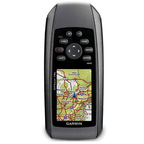
- Stand Out Features - Why We Love It
- Best For: WAAS-enabled GPS receiver and HotFix
- Built-in worldwide Basemap with shaded relief
- Supports geocaching GPX files so you can download geocaches
- Dedicated man overboard function comes handy in an emergency
- Excellent battery life - up to 20 hours on 2 AA batteries
- Floating GPS unit with a IPX7 water resistance rating
Device Type: GPS Navigator
GPS: WAAS-enabled Receiver and HotFix
Mapping: Worldwide Basemap
Display: 2.6 inches, 160 x 240 pixels
Dimensions: 2.6 x 6 x 1.2 inches
Weight: 7.7 ounces
Humminbird 410220-1 Black Fishing Hook
- Stand Out Features - Why We Love It
- Best For: Fish finder with dual beam, down, and side imaging
- Precision internal GPS determines your location accurately
- Basemap delivers incredible details of the underwater terrain
- AutoChart Live enables you to create real-time maps
- Two fish finder display modes—Max and Clear modes
- 5inch color display with backlight for low-light visibility
- Long battery life
Type of Device: GPS Fish Finder
GPS: Internal
Sonar: Dual Beam CHIRP
Dimensions: 15 x 10 x 5 inches
Weight: 3.84 Pounds
Garmin Montana 680 GPS/GLONASS Camera Outdoor
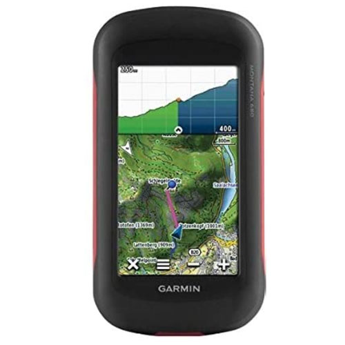
- Stand Out Features - Why We Love It
- Best For: WAAS-enabled GPS, Hotfix, and GLONASS Support
- 8MP autofocus camera automatically geotags photos
- Supports geocaching and includes 250,000 preloaded geocaches
- Comes with a one-year Birdseye Satellite Imagery subscription
- BaseCamp software displays topographic map data in 2-D or 3-D
- 4 inch touchscreen display is sunlight-readable and glove-friendly
Device Type: GPS Navigator
GPS: WAAS-enabled GPS, Hotfix, and GLONASS
Mapping: TOPO U.S 100K
Display: 4 inches 65k color TFT
Dimensions: 1.4 x 2.9 x 5.7 inches
Weight: 10.2 ounces
How To Choose The Best Kayak GPS – Buying Guide
Water Resistance Rating
First and foremost, the best kayak GPS should be water resistant to at least the IPX7 rating. This will enable the device to stand up to splashes, rain, and even accidental submersion for a short duration. On top of this, it’s nice if the device floats on water.
Display Size
The screen on a kayaking GPS device should be large and readable both in direct sunlight and at night. The display size on the compact GPS units for kayaking ranges from 2 to 5 inches. The ideal size to go for will depend on whether you plan to mount the device on your kayak or prefer to carry it in your pocket. A mountable device should have a large screen you can read from the comfort of your seat
Mapping
As the primary purpose of a kayak GPS unit is to track your current location on a map in order to show you where to go, the ideal GPS unit is one equipped with high-quality maps of the area you intend to explore. Some marine GPS units even come equipped with Blue g2 charts of coastal waters. Alternatively, the device should allow you to download, upload, or create your own maps.
Support
It goes without saying that GPS for kayakers should support GPS satellites. Beyond this, a GPS system that also interacts with the GLONASS satellite system is even more reliable in challenging environments. WAAS or Wide Area Augmentation System is also a superior option as this technology transmits the signal repeatedly in order to correct slight errors in the unit’s readings.
You might also like:
Parts of a Kayak – Beginners Guide
FAQs

Q: Why Use A GPS?
To avoid getting lost. As long as you have the best kayak GPS and it's functioning properly and you know how to use it, it's hard to get lost. GPS helps you determine where you are and how to get to your desired destination. Your GPS device can also determine your boat's speed and the depth of the water you're in.
Q: What About Using A Phone?
Yes, a phone also works well at determining your position. However, you need to have access to Wi-Fi or a cellular network in order to use the mapping software on your phone. When you are out of range and need a GPS system most, your phone becomes useless. This is why it's important to have a dedicated GPS device that works off the grid.
Q: What Is The Difference Between Kayak GPS Units And Fish Finders?
Kayak GPS systems function as navigation devices that tell you where you are and where you need to go, while kayak GPS fish finders double as fish finders and also show you what is beneath the water. A GPS for kayak will use satellites to determine your location while fish finders use sonar to locate fish.
Q: Where Should I keep My Kayak GPS?
Depending on the type of device you have, you can mount your kayak GPS on your kayak or stow it in your pocket. Regardless of where you keep it, make sure it's secure and easily accessible when you need it.
Q: Should I Leave My Compass And Map Behind?
Absolutely not! You should always have a map and compass as backup even when you have a state of the art kayak GPS unit. This is because modern electronic can fail – the battery can run out of juice and the device can malfunction. Such a situation will require you to resort to the tried and tested map and compass for navigation.
Q: Can A Kayak GPS Work In The Dark?
Yes, kayak GPS units work well in the dark. The satellite systems work even at night and most kayak GPS units have a backlit display that's easy to read at night.
Q: Does A Kayak GPS Have A Nautical Chart?
Some kayak GPS devices have a nautical chart but most don't have one. This is why it’s important to pay attention to what each device offers. If you need a nautical chart, choose a unit with chart plotting capabilities and pre-loaded charts.
Q: How Can You Attach Or Mount A Kayak GPS?
Most mountable kayak GPS units come with the equipment to use to mount the unit on your kayak. If your unit doesn’t come with mounting hardware, you can always purchase a mount or case to use. If you have a handheld GPS device, you can use clips or a lanyard to attach it to your kayak.
Globo Surf Overview
When it is your safety on the line, having the best GPS system is mandatory. When choosing the best kayak GPS, it’s wise to consider what you plan to use your GPS for and then choose a top rated GPS. Hopefully, our reviews and buying guide have made it easier to find the perfect unit for your needs.
More Kayak Gears:
- Kayak Coolers
- Kayak Drysuits
- Kayaking Gloves
- Kayak Helmets
- Kayak Wetsuits
- Drysuit Undergarments
- Kayak Shoes
- Kayak Paddles
- Kayak Compasses
- Kayak Paddles For Beginners