

-
Best Fish Finder Marine GPS

Best Budget-Friendly Marine GPS

-
1.
-
2.
-
3.
-
4.
It doesn’t seem that long ago when GPS was seen as new technology. It’s easy to forget that there was a time when we didn’t have satellite navigation in our cars or phones which can find out where we are in an instant.
There is now also portable marine GPS systems which can guide you through the water and help locate any fish that might be around. Finding the best marine GPS to suit your needs though can be tricky as they all have different features and finding the top rated boat GPS can be tough.
To help make it easier we have created a buying guide and looked at the marine GPS reviews to come out with a great list of the best devices out there. So read on and find the best boat GPS for you so you can head out on the water in confidence that you can find your way and find that catch.
Best Handheld Marine GPS
Garmin in Reach Explorer+ Handheld Marine GPS
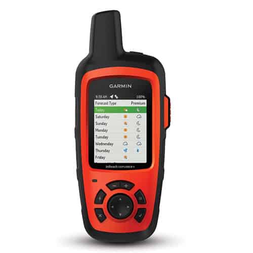
- What Makes This Nautical Gps Stand Out
- Accurate marine GPS location and orienteering
- Equipped with detailed US Topo maps
- Allows you to request marine weather reports
- Reliable two-way satellite texting device
- Built-in compass, altimeter, and accelerometer
- Allows you to track and share your location
- SOS button for triggering search and rescue
- Impressive battery life of 100 plus hours
Best Use: Offshore Boating
Resolution: 200 x 265 pixels
Waterproof Rating: IPX7
Battery Life: 100+ hours
Dimensions: 1.5 x 2.7 x 6.5 inches
Weight: 8 ounces
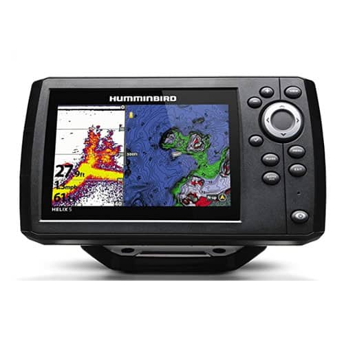
Best Fish Finder Marine GPS
Humminbird 410210-1 HELIX 5 CHIRP G2 Fish Finder Marine GPS
- What Makes This Nautical Gps Stand Out
- Precise GPS/WAAS receiver built in
- A large 5-inch high-resolution screen
- CHIRP digital Sonar fish finding technology
- GPS chart plotting and mapping of fishing sites
- Micro SD card slot for adding maps and waypoints
Best Use: Fishing
Screen: 5″ 256
Resolution: 800Hx480V
Transducer: CHIRP 83 kHz: 75-95 kHz, 200 kHz: 175-225 kHz
Dimensions: 1.13 x 7.55 x 4.28 inches
Weight: 2.5 pounds
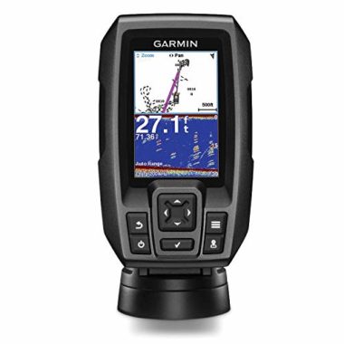
Best Budget-Friendly Marine GPS
Garmin Striker 4 Built-in GPS Fish Finder Marine GPS
- What Makes This Nautical Gps Stand Out
- Best budget marine GPS/fish finder combo
- CHIRP technology delivers incredible detail
- Depth finder, speed data and ice fishing flasher
- High-sensitivity built-in GPS for navigation
- Ability to save waypoints with sonar history rewind
- Mounting hardware included for an easy install
- Portable kit for canoe and kayak fishing
- Very simple and intuitive interface
Best Use: Boat, Kayak, Canoe and ice fishing
Screen: 3.5-inch
Resolution: 480 x 320 pixels
Transducer: CHIRP (77/200 kHz)
Dimensions: 3.6 x 1.6 x 5.9 inches
Weight: 8 ounces
Best 2-In-1 Floating VHF Marine Radio And GPS
Standard Horizon HX870 Floating 6W Handheld VHF Marine GPS
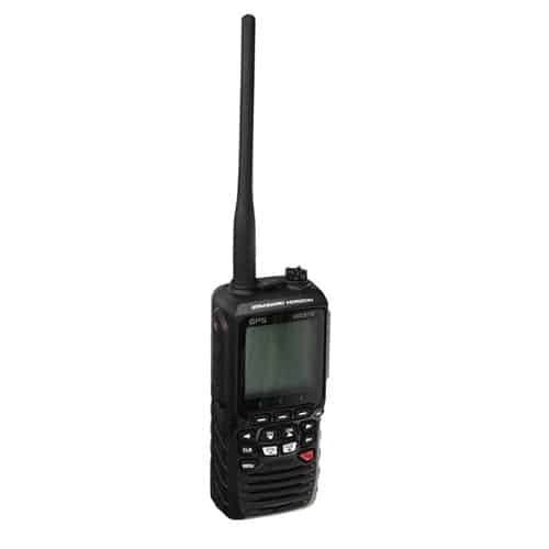
- What Makes This Nautical Gps Stand Out
- Floating handheld VHF marine radio with GPS
- High-sensitivity 66-channel WAAS GPS
- IPX8 waterproof rating, highest on the scale
- An adjustable low battery alarm
- User selectable output power
- Host of marine emergency survival features
- DCS emergency calling capability
- Large, easy to read full dot matrix display
Best Use: Boating, Sailing
Waterproof Rating: IPX8
Weight: 2 pounds
Best Fishing Marine GPS
Lowrance Hook Reveal 5X SplitShot Chirp Transducer Marine GPS
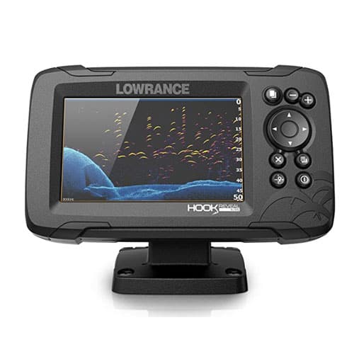
- What Makes This Nautical Gps Stand Out
- Wide-angle CHIRP sonar has superior ability to find fish
- High-resolution DownScan images make fish easy to identify
- Sonar automatically adjust itself depending on conditions
- 5-inch display offers excellent visibility in all conditions
- Simple keypad menu layout for ease of use
Best Use: Fishing
Screen: 5 inch
Weight: 3.24 pounds
Best Boating Marine GPS
Garmin GPSMAP 64x Handheld Marine GPS
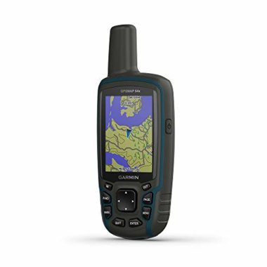
- What Makes This Nautical Gps Stand Out
- Works with GPS, GLONASS and Galileo satellites
- Quad helix antenna and a high-sensitivity receiver
- Portable handheld marine GPS
- Built-in Topo Active maps with the ability to add more
- Integrated compass and barometer altimeter
- Rugged and water-resistant design
- Simple push-button operation and sunlight readable screen
- Battery lasts up to 16 hours in GPS mode
- Runs on alkaline and AA batteries as well
Best Use: Boating, Kayak, Canoe
Screen: 2.6 inches
Screen Pixels: 160 x 240 pixels
Waterproof Rating: IPX7
Battery Life: Up to 16 hours
Dimensions: 6.3 x 2.4 x 1.4 inches
Weight: 8 ounces
Best Kayaking Marine GPS
Garmin eTrex 20x Handheld GPS Navigator Marine GPS
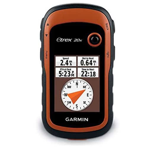
- What Makes This Nautical Gps Stand Out
- Portable and versatile marine GPS navigator
- WAAS-enabled GPS with HotFix and GLONASS
- Ability to add maps custom maps and marine charts
- Worldwide basemap with shaded relief
- High-resolution sunlight readable display
- Supports paperless geocaching GPX files
Best Use: Boating, Kayaking
Screen: 2.2 inches
Resolution: 240 x 320 pixels
Battery Life: 25 hours
Waterproof Rating: IPX7
Dimensions: 2.1 x 4 x 1.3 inches
Weight: 5 ounces
Best Sailing Marine GPS
Garmin GPSMAP 78sc Handheld Waterproof Marine GPS
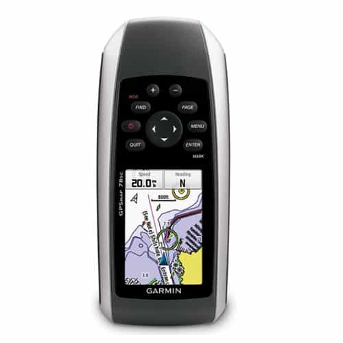
- What Makes This Nautical Gps Stand Out
- Easy to use handheld marine chart plotter
- Pre-loaded with marine maps of the US and Bahamas
- Reliable high-sensitivity GPS tracking
- 3-axis compass and barometric altimeter built-in
- Worldwide Basemap and ability to add your own maps
- 2.6-inch color is easy to read in direct sunlight
- A dedicated man overboard button
- Rugged, waterproof and floating design
Best Use: Sailing
Resolution: 160 x 240-pixel
Waterproof Rating: IPX7
Battery Life: 20 hours (Average)
Screen: 2.6 inches 65K
Device Size: 2.6 x 1.2 x 6 inches
Weight: 7.7 ounces
How To Choose A Marine GPS – Buying Guide
Screen Size And Resolution
With a GPS device you’re going to be reading while on the open water, screen size and resolution are very important considerations. Whether you’re reading marine charts or finding fish, the details should be easy to see in direct sunlight and even when wearing sunglasses. In terms of resolution, the higher the number, the better the picture displayed.
If size and weight isn’t an issue, you can go for a device with the largest screen and the highest resolution. It will be easier on the eyes and you will be able to zoom out the charts easily. Marine GPS handheld for use on a kayak will have a smaller screen but should still be easy to read. All the marine GPS chartplotters we’ve reviewed here have sunlight readable displays.
Power
When you’re going sailing or fishing, your marine chartplotter GPS is an important navigational device. The last thing you want is for it to run out of power. It’s important to find out how the device is powered, and the kind of battery life you can expect.
If you’re planning to install the GPS device on your vessel, you can get a powered system that will utilize your marine battery system. Other marine GPS systems have a rechargeable battery you can recharge with a marine power inverter or even a solar charger. There are also GPS devices that use traditional AA batteries.
Transducers
The transducer is a vital feature to consider when looking at GPS fish finders for a fishing boat. A transducer sends signals into the water and the waves bounce back from things that are in the water such as fish and vegetation, letting you know what is underneath the water around your boat.
When evaluating a transducer, look at its frequencies, beams, power output, and depth range. For the best fish finding capability, opt for a fish finder with CHIRP sonar, as this is superior fish finding technology sure to increase your catch. If you won’t be fishing, you can opt for a marine GPS without fish finder and such a device won’t have a transducer.
Water Resistance
It’s inevitable that your boat or kayak GPS electronic will get wet at some point and you want to be sure that it can withstand water damage and keep working reliably. If you’re mounting the GPS on boat, it should be able to withstand humidity and moisture,
If you’re on a kayak or canoe, you need a waterproof GPS for a boat that will float and can resist damage due to submersion if your kayak capsizes and the device falls into the water. The waterproofing scale ranges from IPX0 to IPX8. A GPS for boat should have an IPX7 or IPX8 water resistance rating.
Navigation Sensors (Barometer and Compass)
Navigation sensors such as barometric altimeter and electronic compass are great to have. A barometer gives your boat navigation system weather predicting capability. It measures atmospheric pressure and can help you predict short-term changes in the weather patterns. This can help you recognize when a storm is approaching and head back to shore. A 3-axis compass built into a GPS device can help you determine the direction you’re heading while on the open water.
Charts And Maps
Since you will be using your marine GPS system for navigation and orientation, it’s important to pay attention to the kinds of charts and maps an ocean GPS device comes with and the kind of details they offer. The charts and maps will help you visualize where your vessel is located on the water.
A device equipped with Topo maps and marine charts for your location is ideal. You can also upload more detailed maps of the water you will be sailing in – make sure the device you get allows you to add maps and is equipped with enough memory or a micro SD slot.
Portability
How much portability you need will depend on where you will be using the GPS device. There are larger devices meant to be permanently installed on a boat and handheld devices that can go anywhere.
If you’re on a canoe or a fishing kayak or enjoying watersports, a portable marine GPS system you can hold in the palm of your hands during use and slip in a pocket when you need your hands free is ideal. Some portable devices even come with a clip or wrist lanyard. There are also versatile GPS devices that don’t require permanent installation so you can use them on multiple vessels.
Reliability
Reliability is the most important consideration when buying a nautical GPS navigation system. Make sure the one you choose is equipped with a high-sensitivity GPS receiver that can lock onto multiple satellites. This will enable it to determine your location fast and accurately no matter where you’re.
It’s smart to opt for a top rated boat GPS by a top brand, so you know you can rely on the GPS device to find your way home. All the GPS for boats we feature in the marine GPS reviews above have reliable and accurate GPS tracking, even in challenging environments.
FAQs
Q: What is a Marine GPS?
A marine GPS is a GPS device designed for use in vessels while at sea. It helps sailors navigate their way through the water. What differentiates an ocean GPS from a regular GPS are the extra features that makes it perfect for use at sea. It’s larger, water resistant, floatable, and equipped with coastal charts to help with steering a boat. Some marine GPS systems also have fish finding capability and navigational sensors such as barometric altimeter and compass.
Q: How Does Marine GPS Work?
A marine GPS tracks your location on the water by interacting with navigational satellites. With the GPS function turned on, your marine GPS system will send a signal to the satellites. The satellites will use the timing and direction the signal came from to determine the precise location of the GPS device. The location coordinates will be displayed on the Marine GPS. If the device is equipped with coastal charts, the coordinates will be placed on a map so you can see your position and what surrounds you.
Q: What Is The Main Purpose Of Your Marine GPS?
A marine GPS is mainly a navigation tool. Its primary purpose is orientation and navigation while at sea. It will show you where you are on the ocean and how to navigate to where you want to go. There are plenty of other uses too. You can use your nautical GPS for geocaching, for voyage planning, and for finding fish if your model has fish finder technology.
Q: Why Orientation Is Important At Sea?
Orientation is vital at sea because it’s easy to get disoriented. The ocean is vast, and there are no roads, signals, or lights to guide your way. There’re plenty of hazards such as waves that can through you off course. This is why it’s always important to know exactly where you are.
A marine GPS is the easiest way to navigate a boat. Without GPS orientation, it would be quite difficult for recreational sailors and anglers to get to where they desire to go and find their way back without getting lost. This is especially important on a large body of water.
Q: Can I Use A Car GPS On My Boat?
While a car GPS uses the same satellites as a marine GPS and can tell you where you’re in the world, it’s not a good idea to use it on a boat, as it’s not tailored for use on the ocean. It won’t be equipped with detailed coastal maps and charts for marine navigation and chart plotting, or fish finder technology to show you what’s underneath the water.
Q: How Do You Read A Marine GPS?
Turn the GPS functionality on and wait for it to lock onto satellites. Once the device determines your location, you will see your location coordinates and the time displayed on the screen. If your device is also a chartplotter equipped with coastal maps, you will see a boat or triangle icon representing your vessel on the map. Zoom in or out on the map to see more specific details of your location.
Q: How Does A Marine Chartplotter Work?
A chartplotter is a marine navigation system that uses GPS satellite navigation and coastal charts to show your precise location on the water. GPS will determine your location but it won’t place it on the marine map. A chartplotter places the GPS coordinates on an electronic chart or map, enabling you to see where your vessel is on the water and monitor your movements.
Globo Surf Overview
Having a boat navigation system is vital in making your way through the waters. Whether you’re looking for a portable marine GPS or an ocean GPS, everything is covered here. If you’re a fan of Garmin boat GPS, there are many options for you. There are also high-quality boat GPS navigation systems, chart plotters, and fish finders by other reputable brands.
There are many considerations when it comes to getting one of the best marine GPS devices. Hopefully, our reviews and buying guide will help you make an informed choice of the best boat GPS for you. Once you’ve picked the best marine GPS system, you’ll be able to head out into the water in confidence that you have a reliable navigation system.
More Boat Reviews:
- Boat Wax
- Boat Covers
- Marine Stereo
- Boat Anchor
- VHF Marine Radio
- Sailing Knife
- Boat Trailer Tires
- Bilge Pump
- Marine Binoculars
- Boat Polish